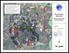
In a joint effort to increase public awareness of flooding in the Armand Bayou watershed, the Clear Lake City Water Authority and the Rice University Severe Storm Prediction, Education and Evacuation from Disasters (SSPEED) Center have provided the flood maps found on the right. As indicated in the title, each map shows the flood levels associated with a given design storm (10 year, 100 year, etc.) and associated storm surge (5 feet, 10 feet, etc.). |
 |