Principal Investigator: Dr. C. Dawson, University of Texas at Austin
Collaborators: Drs. Andrew Kennedy and Joannes J. Westerink, et al - University of Notre Dame and Oakland University
Project Goal: The goal of this project is to investigate the use of petascale computing to significantly advance the state-of-the-art in storm surge simulation, to accurately model flows at multiple, interacting scales at resolution never before attempted and to demonstrate that results from these simulations can be delivered in real-time to emergency managers.
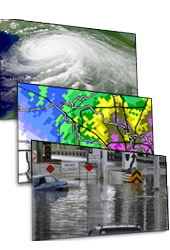
Background: Predicting and studying coastal inundation due to hurricanes and tropical storms is a problem of critical importance to the United States. Hurricane Katrina alone was the costliest and 5th deadliest hurricane in history, with most of the devastation due to wind-driven flooding during the storm. The aftermath of this event has led to a number of federally-mandated studies to determine what failed, the causes of failure, and how to prevent such catastrophes from happening again. Critical decisions will be made in the next several years on how to design better protection systems and improve emergency management practices in the event of future storms.
Storm surge is caused by wind, atmospheric pressure gradients, tides, river flow, short-crested wind-waves, and rainfall. An accurate numerical model of storm surge should account for all of these effects. Such a model can be used in predictive mode as storms approach landfall for the purposes of emergency evacuation and response, and can be used in the design and implementation of improved man-made and natural protection systems for vulnerable coastal areas. Storm surge computer models have been developed extensively over the past decade; however, only within the past few years have the algorithms, computational power and resolution been available to begin to model these events with any reasonable degree of accuracy.
Project Status Report -April 2010
Researchers are using the ADCIRC (Advanced Circulation) model to investigate the storm surge along the upper Texas coast during Hurricane Ike. The ADCIRC model has recently been verified against the high water mark and hydrographic data obtained during and after the storm (see attached Figure). In addition to the actual track of the hurricane, simulations of different landfall locations are being analyzed, varying the location at 10-20 mile intervals east and west of Galveston. This information is then plotted on hydrographs at various locations within Galveston Bay and the Houston Ship Channel. As seen below (See Figures), significant differences in the magnitude of the surge are observed, depending on the precise location of the landfall. These simulations indicate that the maximum surge associated with Ike could have been 2-3 feet higher throughout most of the bay if landfall had been 30-40 miles further west. Current and future work includes: 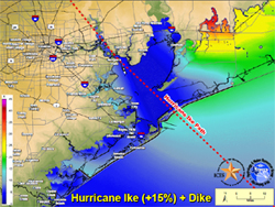
1.) investigating surge characteristics of various proposed protection systems (e.g. the Ike Dike and other dike options) and,
2.) working with Drs. Phil Bedient , Jamie Padgett and Hanadi Rafai to investigate impact of storm surge on infrastructure in the Houston/Galveston metropolitan area and Houston Ship Channel.