
 |
SSPEED Center strategies for the Houston/Galveston Region Modeling Hurricane Ike
The SSPEED Center has identified four areas of impact to focus the next phase of its research: the Houston Ship Channel, the barrier islands and low-lying coastal wetlands and prairies, Galveston Island, and West Bay. The completed research addressing regional hurricane vulnerability will set a national example for coastal protection strategies in terms of economy, social structure, and environmental policy.
This research will enhance understanding about the gate operation before, during and after a storm event. In addition, cost estimates for damage in the area, both economic and environmental, are being developed using damage models at the University of Houston. A variety of scenarios are being run for different surge levels, different rainfalls, and various operational conditions.
Low-Lying Coastal Areas In this economy federal funding for large structural projects is limited and there is an emphasis at the national level to implement projects that combine structural and non-structural alternatives to develop sustainable mitigation techniques. A critical challenge to researchers is how to use low-lying areas of the upper Texas coast in a way that bolsters the local economy while still protecting an ecological reserve.
The low-lying coastal wetlands and prairies of the upper Texas coast provide enormous storage capacity for storm surge. Protecting these areas from unsustainable development will help to protect the greater populated region. The Center is proposing to designate a recreation, conservation and economic development area. Creating a resilient coastal economy based on recreational activities, such as bird watching and kayaking, would give the region unlimited economic and environmental benefits. This designation would also serve to re-invent the coastal economy by packaging and promoting the recreational resources of the whole region, encouraging year-round tourism.
West Bay
The Center is also working to design extensive flood alert systems in coastal communities along bayous west of Galveston Bay. A pilot study is being conducted in the Clear Lake area which is one of the most populated and vulnerable communities along the coast and home to the Johnson Space Center. The flood alert system will be similar to the one developed for the Texas Medical Center which predicts the threat of out-of-bank flooding of Brays Bayou, warning hospitals of the need to take flood protection measures. The coastal prototype will also take into consideration the combination of inland flooding and storm surge, helping to guide pre-event evacuation and post-event re-entry.
The SSPEED Center is also examining the causes and consequences of development in coastal watersheds including how land use change and development patterns drive populations to expose themselves to natural hazards, such as hurricanes. The Center will propose non-structural alternatives in the forms of policy and planning initiatives to address the vulnerabilities of populations living in these areas. In addition, urban planners at the Center are analyzing a series of possible levee systems that will further protect the area west of Galveston Bay. Such a levee system could be aligned along State Highway 146 providing both the opportunity expanded roadway capacity in addition to protection from storm surge. A series of other possible levee alignments are also being analyzed.
Galveston Island and Bolivar Peninsula were significantly damaged during Hurricane Ike. Over 3,000 homes were swept off their slabs during the storm. One of the critical concerns of the SSPEED Center is protecting the populations living adjacent to Galveston Bay. On Galveston Island, the current sea wall provided some protection to the gulf-side of the island during Hurricane Ike; however significant flooding occurred from the bay side of the island. Researchers at the Center are developing protection strategies for Island using sophisticated modeling to represent various levee scenarios. These protection strategies aim to defend against bay side surge which impacted the Strand and historical areas of the island, as well as UT Medical Branch (UTMB) campus.
|
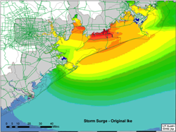 Hurricane Ike is the most destructive hurricane to make landfall on the Texas coast since the Galveston
Hurricane of 1900 and its impact serves as the basis for much of the research conducted by the SSPEED
Center. ADCIRC modelers at the UT Space Science Research Center in Austin are using large-scale
computing to simulate storm surge. They have been able to accurately model Hurricane Ike and predict
approaching hurricanes in real time. They have also begun to complete a series of computer runs that
show the impacts of modified versions of Hurricane Ike (i.e. higher wind speeds, different tracks). The
results allow the evaluation of the relative benefits of implementing a series of structural and non-
structural mitigation techniques to protect coastal areas.
Hurricane Ike is the most destructive hurricane to make landfall on the Texas coast since the Galveston
Hurricane of 1900 and its impact serves as the basis for much of the research conducted by the SSPEED
Center. ADCIRC modelers at the UT Space Science Research Center in Austin are using large-scale
computing to simulate storm surge. They have been able to accurately model Hurricane Ike and predict
approaching hurricanes in real time. They have also begun to complete a series of computer runs that
show the impacts of modified versions of Hurricane Ike (i.e. higher wind speeds, different tracks). The
results allow the evaluation of the relative benefits of implementing a series of structural and non-
structural mitigation techniques to protect coastal areas.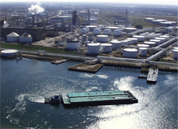 Researchers at the Center are creating advanced computer models to determine the combined storm
surge and inland flooding effects on open and closed gate scenarios. Adcirc surge models are used to
model various hurricane wind and track scenarios. The surge results are input to a hydrologic/hydraulic
model from HEC in order to evaluate important operational and timing issues for gate closure and
opening.
Researchers at the Center are creating advanced computer models to determine the combined storm
surge and inland flooding effects on open and closed gate scenarios. Adcirc surge models are used to
model various hurricane wind and track scenarios. The surge results are input to a hydrologic/hydraulic
model from HEC in order to evaluate important operational and timing issues for gate closure and
opening.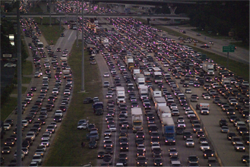 Currently 1.2 million people are living in the coastal evacuation zones and an additional 700,000 are
projected to move into the zones by 2035 (HGAC 2007). These numbers will overwhelm the capacity of
the road system and emergency managers' ability to adequately evacuate these areas in advance of a
hurricane event. The Houston Galveston Area Council estimates that it would take 36 hours to evacuate
1 million residents under perfect conditions. It will be critical to develop an evacuation plan with enough
lead-time. The Center is working to increase community awareness about the region's vulnerability to
storm surge and flooding through educational initiatives.
Currently 1.2 million people are living in the coastal evacuation zones and an additional 700,000 are
projected to move into the zones by 2035 (HGAC 2007). These numbers will overwhelm the capacity of
the road system and emergency managers' ability to adequately evacuate these areas in advance of a
hurricane event. The Houston Galveston Area Council estimates that it would take 36 hours to evacuate
1 million residents under perfect conditions. It will be critical to develop an evacuation plan with enough
lead-time. The Center is working to increase community awareness about the region's vulnerability to
storm surge and flooding through educational initiatives.